


1、Stratum
The geopark area is basically covered by sedimentary rocks with the sedimentary thickness of 2250-2550m, which is divided into 16 official stratum units (Table1-1).
表1-1 织金地区地层划分简表
| 年代地层 | 岩石地层 | |||
| 系 | 统 | 名称 | 代号与接触关系 | |
| 第四系 | 全新统 | Qh | ||
| 更新统 | Qp | |||
| 三叠系 | 下统 | 关岭组 | T1g | |
| 永宁镇组T1yn | 第四段 | T1yn4 | ||
| 第三段 | T1yn3 | |||
| 第二段 | T1yn2 | |||
| 第一段 | T1yn1 | |||
| 夜朗组T1y | 九级滩段 | T1y3 | ||
| 黄椿坝段 | T1y2 | |||
| 沙堡湾段 | T1y1 | |||
| 二叠系 | 上统 | 大隆组 | P3d | |
| 长兴组 | P3c | |||
| 龙潭组 | 第二段 | P3l2 | ||
| 峨眉山玄武岩 | P3β | |||
| 第一段 | P3l1 | |||
| 中统 | 茅口组 | P2m | ||
| 栖霞组 | P2q | |||
| 下统 | 梁山组 | P1l | ||
| 石炭系 | 下统 | 摆佐组 | C1b | |
| 大塘组 | C1d | |||
| 寒武系 | 下统 | 金顶山组 | ∈1j | |
| 明心寺组 | ∈1m | |||
| 牛蹄塘组 | ∈1n | |||
| 震旦系 | 上统 | 灯影组 | Zbd | |
说明:按中国区域年代地层(地质年代)表(2001),栖霞组、茅口组分属中二叠统和上二叠统,但为了研究方便,仍沿用旧的地层代码,以下相同。
Table 1-1 List of Stratigraphic Division in Zhijin Area
| Geochronologic unit | Lithostratigraphic unit | |||
| System | Series | Name | Code and Contact Relation | |
| Quaternary system | Holocene series | Qh | ||
| Pleistocene series | Qp | |||
| Triassic system | Lower | Guanling Formation | T1g | |
| Yongningzhen Formation (T1yn) | Fourth member | T1yn4 | ||
| Third member | T1yn3 | |||
| Second member | T1yn2 | |||
| First member | T1yn1 | |||
| Yelang Formation (T1y) | Jiujitan member | T1y3 | ||
| Huangchunba member | T1y2 | |||
| Shabaowan member | T1y1 | |||
| Permian System | Upper | Dalong Formation | P3d | |
| Changxing Formation | P3c | |||
| Longtan Formation | Second member | P3l2 | ||
| Emeishan Basalt | P3β | |||
| First member | P3l1 | |||
| Middle | Maokou Formation | P2m | ||
| Qixia Formation | P2q | |||
| Lower | Lianshan Formation | P1l | ||
| Carboniferous system | Lower | Baizuo Formation | C1b | |
| Datang Formation | C1d | |||
| Cambrian system | Lower | Jindingshan Formation | ∈1j | |
| Mingxinsi Formation | ∈1m | |||
| Niutitang Formation | ∈1n | |||
| Sinian system | Upper | Dengying Formation | Zbd | |
Note: according to the geochronologic unit (geologic age) table (2001) of China, Qixia Formation and Maokou Formation belong to Middle Permian series and upper Permian series respectively; however, for the convenience of research, the old stratum code is to be used, and the following are the same.
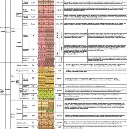
In the exposed stratum of geopark, Yelang Formation and Yongningzhen Formation of Lower Triassic series dominate, with the total thickness of greater than 300m, and they distribute in the shape of strip piece. They are horizontally separated by coal measure strata of upper Permian series and shale stratum of Triassic System,and are vertically separated by soluble stratum (Huangchunba Member) and unsoluble stratum (Shabaowan Member and Jiujitan Member) of Lower Triassic series, to form distinctive aquiclude structure with coexistence of both horizontal
and vertical aquiclude.
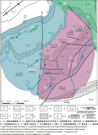
Figure 2-1 Areal Geology Diagram of Guizhou Zhijindong Cave Geopark (according to Fu Zichong, et al. 1989)