


Hydrogeology
The geopark belongs to bared and semi-bared karst mountainous area, where karst developes very well and absorptive capacity of atmospheric precipitation is very strong, and atmospheric precipitation is the main supply source of underground water. Most of them directly supplies underground water via surface negative landform such as gorge, depression, sinkhole, tiankeng, vertical shaft and doline, etc., some of them infiltrates through fissures and joints, and forms karst fissure water to
indirectly supply underground water.
The temporal surface water, which forms after rainfall, mainly supplies underground water and flows in two circular manners: surface karst water (rain water→surface overland flow→dispersedly flowing along surrounding lowland and depression, or flowing into surrounding karst surface rivers) and underground karst water (rain water→infiltrates and forms karst fissure water→continues infiltrating and supplies underground river (some oozes from wall rock of cave) →underground river
→karst surface river).
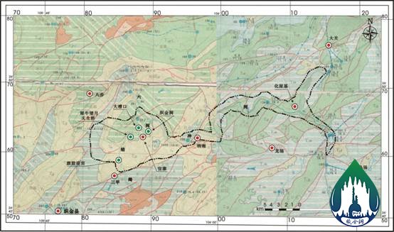
At present, the underground water and surface water within the geopark area basically converge at Qijiehe River at first, and then discharge to Liuchonghe River. Liuchonghe River, as the catchment channel of karst underground water within the area, plays a role to discharge almost all the regional underground water and surface water, which is of highly-focused discharge characteristic. Therefore, the whole geopark is equipped with complete supply, run-off, discharge and boundry conditions,
and unified karst aquifer, which belongs to a complete hydrogeological unit.